Dawson Geophysical Co
From Wikimarcellus
| Revision as of 05:04, 17 March 2009 Tcopley (Talk | contribs) ← Previous diff |
Revision as of 05:04, 17 March 2009 Tcopley (Talk | contribs) Next diff → |
||
| Line 13: | Line 13: | ||
| A seven- to eight-person crew runs several miles of data lines that are connected to vibration sensors, which are strategically placed along the line by using a global positioning system. Vibrations are then sent into the ground by “thumper trucks” that drive along the route and the sensors record impulses that return. After the data are gathered, they are sent to Dawson’s data processing center in Midland to be interpreted by analysts, who produce three-dimensional seismic data for major and independent oil and gas companies. | A seven- to eight-person crew runs several miles of data lines that are connected to vibration sensors, which are strategically placed along the line by using a global positioning system. Vibrations are then sent into the ground by “thumper trucks” that drive along the route and the sensors record impulses that return. After the data are gathered, they are sent to Dawson’s data processing center in Midland to be interpreted by analysts, who produce three-dimensional seismic data for major and independent oil and gas companies. | ||
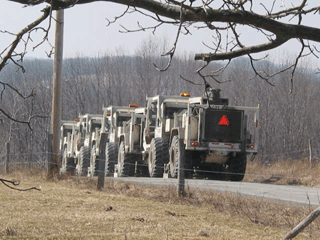
| - | <center>http://www.sonic.net/~tcopley/img/thumper3.gif <br>'''A convoy of Dawson ''thumper trucks''<br>disappears down a country road near Springville, PA.'''<br>Courtesy of Peter Comly, ''Clodhopper Farm''[http://clodhopperfarm.blogspot.com/]</center> | + | <center>http://www.sonic.net/~tcopley/img/thumper3.gif <br>'''A convoy of Dawson ''thumper trucks''<br>disappears down a country road near Springville, PA.'''<br>Courtesy of Peter Comly, ''Clodhopper Farm''</center> |
| The data provide a blueprint of the subsurface geology, diminishing the probability of marginal and dry well locations, according to Dawson’s Web site. | The data provide a blueprint of the subsurface geology, diminishing the probability of marginal and dry well locations, according to Dawson’s Web site. | ||
Revision as of 05:04, 17 March 2009
Here is where some info about Dawson Geophysical Co.
should go.  This article is still a stub and needs your
attention. It does not have a template and contains minimal
information. Please dive in and help it grow!
Dawson Geophysical Co. has pending applications before county officials to do seismic testing in the towns of Conklin, Binghamton and Kirkwood in Broome County, New York.
In December, 2008 the company was reported doing seismic testing in the Scranton, Pennsylvania area. According to the thedailyreview.com [2], the procedure followed went like this:
A seven- to eight-person crew runs several miles of data lines that are connected to vibration sensors, which are strategically placed along the line by using a global positioning system. Vibrations are then sent into the ground by “thumper trucks” that drive along the route and the sensors record impulses that return. After the data are gathered, they are sent to Dawson’s data processing center in Midland to be interpreted by analysts, who produce three-dimensional seismic data for major and independent oil and gas companies.
A convoy of Dawson thumper trucks
disappears down a country road near Springville, PA.
Courtesy of Peter Comly, Clodhopper FarmThe data provide a blueprint of the subsurface geology, diminishing the probability of marginal and dry well locations, according to Dawson’s Web site.
A January, 2009 report stated that Dawson planned to conduct seismic testing in several Pennsylvania Counties including Lackawanna (Clarks Summit and downtown Scranton), Luzerne, Pike, Susquehanna, Wayne and Wyoming.
The company maintains seismic data processing centers in Houston and Midland, Texas as well as Oklahoma City, Oklahoma.
Dawson's home office is in Midland, Texas.
Stephen Jumper is the compnay's President and CEO.
Contact: Douglas Holmes, Permit Agent for Dawson.


