Big Sandy Field
From Wikimarcellus
(Difference between revisions)
| Revision as of 21:39, 5 March 2011 Tcopley (Talk | contribs) (covers approximately 1.5 million acres that span the states of Kentucky and West Virginia) ← Previous diff |
Revision as of 21:40, 5 March 2011 Tcopley (Talk | contribs) Next diff → |
||
| Line 1: | Line 1: | ||
| - | [[Image:big_sandy2.gif|center|frame|<div align="center">Map of '''Big Sandy Natural Gas Field'''<br>Map courtesy of [http://www.blueflameenergy.com/ Blue Flame Energy Corp]</div>]] | + | [[Image:big_sandy2.gif|left|frame|<div align="center">Map of '''Big Sandy Natural Gas Field'''<br>Map courtesy of [http://www.blueflameenergy.com/ Blue Flame Energy Corp]</div>]] |
| The '''Big Sandy Field''' covers approximately 1.5 million acres that span the states of Kentucky and [[West Virginia]]. It is under-girded by the ''Ohio Formation'', a ''Devonian Age'' fractured shale, rich in organic content, that ranges between 500 and 1,800 feet thick. | The '''Big Sandy Field''' covers approximately 1.5 million acres that span the states of Kentucky and [[West Virginia]]. It is under-girded by the ''Ohio Formation'', a ''Devonian Age'' fractured shale, rich in organic content, that ranges between 500 and 1,800 feet thick. | ||
Revision as of 21:40, 5 March 2011

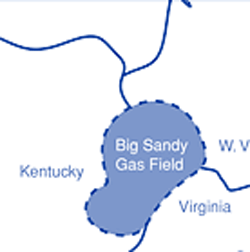
Map of Big Sandy Natural Gas Field
Map courtesy of Blue Flame Energy Corp
Map courtesy of Blue Flame Energy Corp
The Big Sandy Field covers approximately 1.5 million acres that span the states of Kentucky and West Virginia. It is under-girded by the Ohio Formation, a Devonian Age fractured shale, rich in organic content, that ranges between 500 and 1,800 feet thick.

