Seismic testing
From Wikimarcellus
| Revision as of 21:19, 2 May 2009 Tcopley (Talk | contribs) ← Previous diff |
Revision as of 22:27, 2 May 2009 Tcopley (Talk | contribs) Next diff → |
||
| Line 1: | Line 1: | ||
| - | '''Seismic testing''' or ''surveying'' is a technology used to search for pockets of natural gas. High tech ''vibrator trucks'' crawl along rural roads of Appalachia and send [[seismic waves]] into the surrounding ground in order to discover geologic formations under fields, farms and homes. | + | '''Seismic testing''' (aka seismic ''mapping'' or ''surveying'') is a technology used to search for pockets of natural gas. High tech ''vibrator trucks'' crawl along rural roads of Appalachia and send [[seismic waves]] into the surrounding ground in order to discover geologic formations under fields, farms and homes. |
| <center>http://www.sonic.net/~tcopley/img/thumper2.gif <br>'''A convoy of thumper trucks cruises<br>down a country road near Springville, PA'''<br>Courtesy of Peter Comly, [http://clodhopperfarm.blogspot.com/ - ''Clodhopper Farm'']</center> | <center>http://www.sonic.net/~tcopley/img/thumper2.gif <br>'''A convoy of thumper trucks cruises<br>down a country road near Springville, PA'''<br>Courtesy of Peter Comly, [http://clodhopperfarm.blogspot.com/ - ''Clodhopper Farm'']</center> | ||
| Line 8: | Line 8: | ||
| Workers clear the vegetation and mulch down 4 ft. wide paths in a grid pattern throughout the woods being surveyed. Microphones are then connected via bright orange cables along the paths. Vibrator units mounted on buggies emit sound waves that go approximately five miles down into the ground. These waves reflect back off of underground rock formations, and are picked up by the microphones. The seismic data produced is then studied in order to decide where to drill.</blockquote> | Workers clear the vegetation and mulch down 4 ft. wide paths in a grid pattern throughout the woods being surveyed. Microphones are then connected via bright orange cables along the paths. Vibrator units mounted on buggies emit sound waves that go approximately five miles down into the ground. These waves reflect back off of underground rock formations, and are picked up by the microphones. The seismic data produced is then studied in order to decide where to drill.</blockquote> | ||
| - | The conventional wisdom on seismic testing is that it won’t tell you exactly which location to drill, but may help you figure out where not to. | + | The seismic data is used to computer generate or render 2-D and 3-D maps of the underlying rock formations up to a depth of 30,000 feet. A skilled analyst can gain some idea of the liklihood of finding gas in a particular area by reading these maps. |
| + | |||
| + | The conventional wisdom on seismic testing is that it won’t tell you exactly which locations to drill, but may help you figure out where not to. | ||
Revision as of 22:27, 2 May 2009
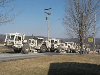
Seismic testing (aka seismic mapping or surveying) is a technology used to search for pockets of natural gas. High tech vibrator trucks crawl along rural roads of Appalachia and send seismic waves into the surrounding ground in order to discover geologic formations under fields, farms and homes.

A convoy of thumper trucks cruises
down a country road near Springville, PA
Courtesy of Peter Comly, - Clodhopper Farm
A typical seismic survey in a forest preserve was described this way:
Workers clear the vegetation and mulch down 4 ft. wide paths in a grid pattern throughout the woods being surveyed. Microphones are then connected via bright orange cables along the paths. Vibrator units mounted on buggies emit sound waves that go approximately five miles down into the ground. These waves reflect back off of underground rock formations, and are picked up by the microphones. The seismic data produced is then studied in order to decide where to drill.
The seismic data is used to computer generate or render 2-D and 3-D maps of the underlying rock formations up to a depth of 30,000 feet. A skilled analyst can gain some idea of the liklihood of finding gas in a particular area by reading these maps.
The conventional wisdom on seismic testing is that it won’t tell you exactly which locations to drill, but may help you figure out where not to.

