Seismic waves
From Wikimarcellus
| Revision as of 04:17, 17 March 2009 Tcopley (Talk | contribs) ← Previous diff |
Revision as of 04:19, 17 March 2009 Tcopley (Talk | contribs) Next diff → |
||
| Line 1: | Line 1: | ||
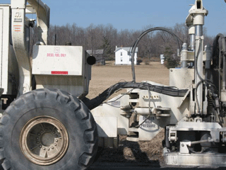
| + | '''Seismic waves''' are emitted by ''vibrator'' or ''thumper trucks''. These vehicles are specially equipped with an impact device, a large, metal, earth-vibrating foot, that generates ground waves. | ||
| + | |||
| <center>http://www.sonic.net/~tcopley/img/thumper0.gif <br>'''Impact device<br>Courtesy of Peter Comly, ''Clodhopper Farm''[http://clodhopperfarm.blogspot.com/]</center> | <center>http://www.sonic.net/~tcopley/img/thumper0.gif <br>'''Impact device<br>Courtesy of Peter Comly, ''Clodhopper Farm''[http://clodhopperfarm.blogspot.com/]</center> | ||
| - | '''Seismic waves''' are emitted by ''vibrator'' or ''thumper trucks''. These vehicles are specially equipped with an impact device, a large, metal, earth-vibrating foot, that generates ground waves. | + | |
| + | The trucks are driven down rural highways in areas where gas is suspected, and have electronic equipment on board to record the returns when sound waves bounce back from underground features. | ||
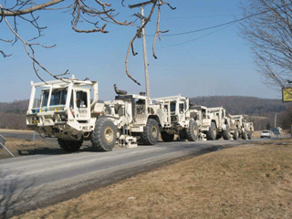
| <center>http://www.sonic.net/~tcopley/img/thumper1.gif <br>'''Convoy of four thumper trucks<br>sending seismic shock waves down through the road.<br>Courtesy of Peter Comly, ''Clodhopper Farm''[http://clodhopperfarm.blogspot.com/]</center> | <center>http://www.sonic.net/~tcopley/img/thumper1.gif <br>'''Convoy of four thumper trucks<br>sending seismic shock waves down through the road.<br>Courtesy of Peter Comly, ''Clodhopper Farm''[http://clodhopperfarm.blogspot.com/]</center> | ||
| - | The trucks are driven down rural highways in areas where gas is suspected, and have electronic equipment on board to record the returns when sound waves bounce back from underground features. Usually, the survey area is carefully staked and marked with colored flags serving as measurement markers. Yellow and black fiber optic cables run beneath the markers, connected to vibration sensor units spaced at intervals along the cables. Readings from the sensors help map out the boundaries of the underground rock formations. | + | Usually, the survey area is carefully staked and marked with colored flags serving as measurement markers. Yellow and black fiber optic cables run beneath the markers, connected to vibration sensor units spaced at intervals along the cables. Readings from the sensors help map out the boundaries of the underground rock formations. |
| Reports often state that the noise and vibrations from thumper trucks can be heard for a considerable distance. The trucks work in groups of three or four, one right behind the other, and the impacts they generate are synchronized. | Reports often state that the noise and vibrations from thumper trucks can be heard for a considerable distance. The trucks work in groups of three or four, one right behind the other, and the impacts they generate are synchronized. | ||
Revision as of 04:19, 17 March 2009
Seismic waves are emitted by vibrator or thumper trucks. These vehicles are specially equipped with an impact device, a large, metal, earth-vibrating foot, that generates ground waves.
The trucks are driven down rural highways in areas where gas is suspected, and have electronic equipment on board to record the returns when sound waves bounce back from underground features.

Convoy of four thumper trucks
sending seismic shock waves down through the road.
Courtesy of Peter Comly, Clodhopper Farm[2]
Usually, the survey area is carefully staked and marked with colored flags serving as measurement markers. Yellow and black fiber optic cables run beneath the markers, connected to vibration sensor units spaced at intervals along the cables. Readings from the sensors help map out the boundaries of the underground rock formations.
Reports often state that the noise and vibrations from thumper trucks can be heard for a considerable distance. The trucks work in groups of three or four, one right behind the other, and the impacts they generate are synchronized.
The basic idea is to use the data collected to build a representational model of geological limits of the gas deposit.
Information from seismic studies has occasionally been used for leverage in land negotiations between gas companies and landowners.


